HAToM is a disruptive geospatial data visualisation platform that translates geospatial data and complex graphics into a universal “visual” language that everybody can understand, regardless of their specialisation. The core…
Read More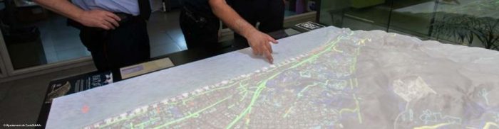
HAToM is a disruptive geospatial data visualisation platform that translates geospatial data and complex graphics into a universal “visual” language that everybody can understand, regardless of their specialisation. The core…
Read More
TSAR AI assists emergency authorities to detect the effects of natural disasters by automating the processing of satellite imagery with Artificial Intelligence. Emergency responders can detect even small changes to…
Read More
Linda Forest provides a step-change in the accuracy of wood mass prediction in standing forests by applying Artificial Intelligence (AI) to satellite, geology and other data. Forestry firms currently spend…
Read More
Data in Use Formosat-2, Spot-5, and Pleiades TerraSAR-X (DLR) Service summary BALIST is a service under development funded by the Aquitaine Regional Council (APSAT / INTERREG SUDOE IVb project). It…
Read More
Data in Use Preferred 0.5m resolution or better; two layers, panchromatic or (ideally) infrared and RGB Service summary Cerberus is a crowdsourcing and e-learning platform where participants are involved in…
Read More
Data in Use Satellite radar images and in-situ photos Service summary Satellite radar images in urban areas require in-situ verification due to backscatter. After asking the public for help, we…
Read More
Data in Use SAR satellites with multi-polarisation capabilities – including Sentinel-1 and Cosmo-Skymed for flood monitoring – along with radar altimetry data sets from such sources as Jason 2 and…
Read More


