SaferPlaces provides actionable insights to predict flood risks in any city worldwide. Due to increasing anthropogenic pressure from factors like soil sealing and the more frequent occurrence of extreme weather…
Read More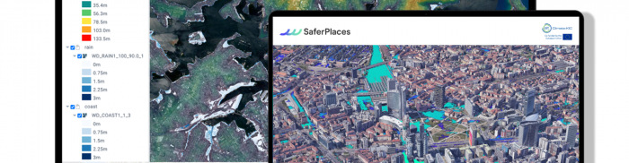
SaferPlaces provides actionable insights to predict flood risks in any city worldwide. Due to increasing anthropogenic pressure from factors like soil sealing and the more frequent occurrence of extreme weather…
Read More
The higher availability of satellite imagery has improved the collection of information on crop conditions. This kind of data, however, only provides a valid alternative to traditional crop scouting when…
Read More
U-GEO is an algorithm based on machine learning that combines Copernicus data with urban planning, resource management, and green infrastructure. It is designed to help create efficient green infrastructure and…
Read More


